BRNO 2018-2040
Developing a new community

Fig. 1 Brno, by E.Gurk and J.Sand
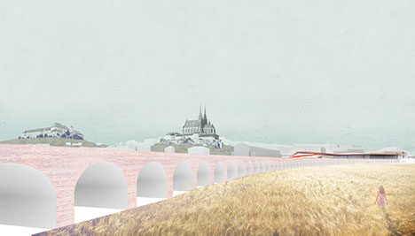
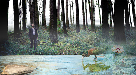
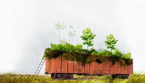
Fig. 2 Brno, 2023, rehabilitation of the old railway structure and the phytoremediation process
1.0 URBAN DESIGN AND THE QUALITY OF PUBLIC SPACES
1.1 SHAPING THE 2040 URBAN GENERATION
The proposed development plan for the new (extended) city centre of Brno uses the exceptional potential offered by the 122 hectare void located at the historic heart of the city. The same way as districts have grown around the castle and the cathedral throughout the centuries the railway terminal became another important node albeit with a dividing character: towards the castle, facing the square, the building shields what exists behind it, the tracks and towards the outskirts the utilitarian images of transportation and logistics - an urban periphery at the very centre of the city.
Former villages surrounding the fortified old town have grown into the districts of Brno. After the demolition of the city walls the glacis was partly urbanized and the railway terminal occupied its present position within the fabric of the city. Facing the old town a magnificent square… Behind the terminal, along the railway tracks, industries settled partly utilizing the river as a source of water for production. Surrounded by the marshaling yard a ‘no man’s land’ remained largely intact. Since the air raids of WWII erased much of the industrial past the void became more pronounced, but never reutilized for urban functions. A forgotten urban meadow...
The current status of the area is a result of this contradiction of location and functionality: a central lying periphery. Crossed by a densely trafficked thoroughfare with fragments of a predominantly industrial vernacular and some workers tenements surrounding the void/meadow, the area that is now covered by green vegetation. This ‘wrong part of the railway station’ (which exist everywhere where railways cut through cities) with the advent of capitalism, following the political and economic changes of 1989, this area started to ‘regenerate’ with new retail functions taking over land and structures occupied by former industrial uses just behind the railway station. The rest of the area remained unbuilt, with green vegetation and bits of concrete surfaces along highway 42, where automobile oriented uses (parking, trucking terminal, etc.) are located.
The proposed new Brno Centre aims to sustain this green heart character that would contribute to a new urban microclimate. As the city already has a dense urban fabric, this project provides Brno with a new green infrastructure that has the same programmatic diversity in building types, public spaces and green areas but providing not yet existing alternatives for the residents of Brno, while weaving ‘torn apart’ fragments into a unified urban fabric again. Following a vision of living, compact neighbourhood providing a variety of housing and adjoining services the plan sets out a structural and functional framework for a living urban organism to gradually follow this DNA similarly as the other neighbourhoods adjoining Brno’s central core have developed through the centuries.
The size of the area and the vision of a living city calls for a range of functions interrelating and supporting each other while providing a variety for a number of potential target groups wishing to settle in the city. In fact the ambition of the proposal is to attract all combinations of households, young and old, single or multi-generational providing a financially affordable and far more eco-friendlier alternative to suburbanizing for the often unrealistic dream of ‘living in the greens’. The project envisions a reduction from the current volume of commuters at 110 thousand to 90 thousand with a growth of population stabilizing at 400 thousand. To enable the re-urbanisation of suburbanite commuters by providing a variety of housing typologies and tenure options. The functional composition ambitions a living city with mixed uses. Besides housing new workplaces and services are located in the new neighbourhood. Allowing the transposition of activities generates a new urban energy while maintaining high quality of living: residential+workplace / commercial+manufacturing / urban industry+cultural / “found places”- under the rail tracks - cargo handling…
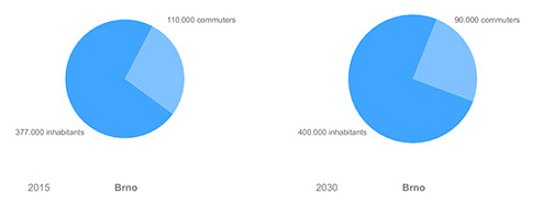
Fig. 3 Expected demographic change
The resiliency of design is experimented by allowing for later function changes as the plan realization unfolds (residential/office/retail). For a living city there is a great importance of Ground floor and first floor levels. “Ground floors should be diverse and should offer constantly changing, vibrant, engaging, and welcoming environments. High streets need to adapt or wither as shopping is no longer the sole desirable activity of a town centre. People want interesting things to see and do–that don’t cost a fortune. And increasingly they want to do their shopping online, or in suburban retail hubs. We can’t change that. But we feel meanwhile use is a good way to test new uses on the high street and through meanwhile, we can help our high streets to adapt to an uncertain future and to become places that people want to spend their time again.” (Stipo - City at Eye Level) The Amsterdam group Stipo has invented the term “the Plinth” to describe this street ecosystem based on the notion that humans interact “at eye level”. On lively streets the ground floor plays a part as an extension of public space whereas public space acts as an extension of private space. Thus smart design is embedded in the urban form (augmented by smart technologies allowing for sustainable operation and higher level of comfort for citizens). Supporting small businesses is resulted by maintaining the human scale.
1.2 PUBLIC SPACE DESIGN RULES
- no underground parking entrance faces public spaces;
- allowing/facilitating programming on the streetscape;
- programmatic design of courtyards, inner gardens in certain periods of time allowing
for residents to control their privacy;
- verticality - public space may also appear on upper floors;
- priority order of mobility: pedestrians first and then bicycle - public transport - private
car;
- nature extensively appears as a primary public space shaping factor.
1.3 MATERIAL USE
- promoting pedestrian friendly materials,
- connected surface treatment: road and building walls may appear as continuum,
- shared space vs. segregated pathways according to the level of traffic,
- high standard, durable materials, simple details in public spaces (easy to maintain but
providing comfort and aesthetically pleasing environment).
1.4 ZERO ENERGY AMBITIONS
Since the execution of the building program shall commence over 22 years the programming anticipates a radical change from fossil based fuel consumption to renewable resources.
The building typologies therefore are placed according to solar analysis. Maximum use of passive solar gains and the issues related to ventilation is considered at each phase of the development: e.g. phase 1 - planting high-grown energy grass in the phytoremediation process, that could be used as a primary energy source for heating in the community centres.
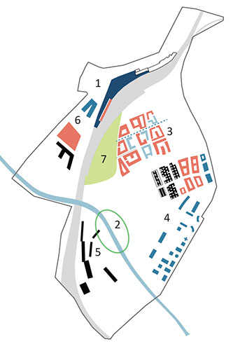
Fig. 4 The 7 development areas:
1. Urban Mobility Hub (main railway station) 2. Urban Greens (river + wetland)
3. New Urban Living (adjacent to the existing retail complex) 4. Makerspace and
City Logistics 5. University Campus & Innovation Centre 6. Mixed Use Triangle
(housing, sport venue, bus parking) 7. Brno Festival Park
The main railway station
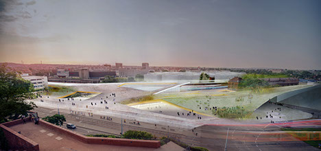
Fig. 5 The main the railway station and the surrounding public space as an extension of the
existing urban structure
Developing the former shooting ground surrounding the fortifications (the Glacis) allowed for the creation of magnificent urban parks and also the development of the railway system that accessed the city from the South. To reinforce and preserve continuity around the Brno Ring the new building station faces the historical city with its fifth facade. Passengers enter the building through the extended public space above the waiting room. The undulating surface of the station building follows the topography of the surrounding areas and creates walkable passages and terraces among the important landmark buildings and the main public spaces along the edge of the southern historical city. The point of transit becomes a destination, a place to stay and enjoy in itself. A viewing terrace of the busy life around and below it. An architectural landscape that does not conquer with the historic landmarks and by doing so becomes an equally strong contemporary landmark for the city.
The station building and the railway structures are no longer dividing urban elements between neighbourhoods as the station creates a spatial structure that connects these areas turning the dividing infrastructure into a playful flow of connectivity. There are 3 exits on the platforms: (1) central exit at the new main building, directly connecting to all transport possibilities (2) southern exit at the Little America, connections to the cultural and retail venues within the building and to the car parking below (3) eastern exit at the old station building that is converted into a hotel and with extra retail and dining facilities. The main entrance of the station building provides access towards the new urban district Brno Centre.Connectivity under the sloping walkable roof structure is key as the station now also include both railway and bus terminals. Along the station the tram lines are rationalized easing the dense traffic providing more comfort for transit passengers.
The spatial structure of Nadrazní extends by the gentle slope of the station building, a walkable roof, leading to the terrace towards Little America. Below a simple, passenger friendly spatial arrangement allows for smooth transition between all rail and bus services: local, regional, international. This artificial but tame landscape does not obstruct the majestic view of the cathedral neither from the inside - as the skylight opens up the panorama towards Petrov hill. From the area ‘behind’ the station, i. e. the new Brno Centre district’s Festival Park the gently sloping structure follows the silhouette of Petrov hill and offers the same emphasis visually as towards the main square. By this gesture it not only connects the two sides physically, but in terms of dignity the new neighbourhood gets a strong architectural emphasis giving a fresh start for a new urban future for this formerly underutilized part of town.
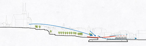
Fig. 6 Diagram of the new extended public space over the main station
Resilience of the design
3.1 STAGE 1 - 2018
Start of the 2 flagship projects: Brno Railway Station with the reorganized surface railway tracks and the Urban Greens (river + wetland) that is the core of the green and recreational development.
The green area determines where the bio+phytoremediation process is proposed.
Start of the 2 flagship projects: Brno Railway Station with the reorganized surface railway tracks and the Urban Greens (river + wetland) that is the core of the green and recreational development.
The green area determines where the bio+phytoremediation process is proposed.
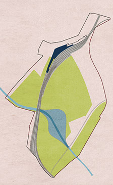
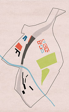
Fig. 7 Stage 1
Fig. 8 Stage 2
3.2 STAGE 2 - 2023
- First phase of the New Urban Living district, with the given proportions of affordability.
- Recreational body culture park around the cargo
- Community gardens, experimental agriculture and urban farming (vegetation+animals)
- University Campus & Innovation Centre
- Mixed Use Triangle
- Under-track Arcades, retail and cultural venues
3.3 STAGE 3 - 2030
- Second phase of the New Urban Living district
- Community-based public space design
- Experimental housing: active houses that are decentralized energy batteries
- Brno Festival Park
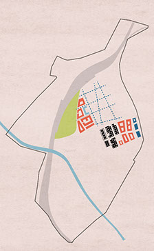
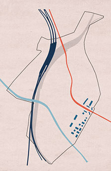
Fig. 9 Stage 3
Fig. 10 Stage 4
3.4 STAGE 4 - 2040
The completion of the 2 long-term railway projects: the high-speed train, Horizon 2040, and the North-South Diameter.
By connecting the ex-cargo theme park into the city transport system, the area will become available for office and tertiary-quarter- nary sector developments, where high-rise buildings would create a new urban fabric at the edge of the competition area.
3.5 EQUIPMENTS OF RESILIENCY
Resiliency + People: (diverse population living in the new quarters)
Resiliency + Program: (multiple uses, housing, workplaces, commerce, leisure/culture)
Resiliency + Community (public engagement in planning and operation)
Resiliency + creation of new service jobs
hotel / accommodation / retail / sports and cultural amenities require personnel
Resiliency + creation of green jobs for park maintenance
maintenance of parks and wetland creates job
Resiliency + improved public space
- bioswales, attractive stormwater buffers
- body culture - board games - sports
- vegetable / flower garden
- orchards
- flood protection as public space
- living streets (‘the plinth’ principle)
Resiliency + addition of more amenities
- new buildings including a variety of services
- emphasis on inviting and active ground floors (retail, catering, services)
- community centres as hubs for regeneration by using existing structures and facilitating
stakeholder and civic dialogue and engagement
- amenities on berm (sports, leisure, nature)
- energy plant (renewables)
Resilience + spatial flexibility
buffer zones at the perimeter of the site allow for adaptive reprogramming
(cargo area, university/technology campus zone).
Resilience + implementation
- multiple stakeholders (municipality, agencies, developers, community groups),
- multiple level process management
- public spaces are developed involving private sector and the community
- municipal coordination and support
Green infrastructure
The proposed urban development comprises two landscapes in juxtaposition: an artificial “meadow” or terrace (the railway station) that reconnects the new developments with the historic city centre and the ‘urban wildlife’ and cultivated green recreational areas that serves as a natural connection between the river and the planned built up areas of Brno City Centre. The green/landscape elements also orient the development as it unfolds in phases during the years:
Phase 1
decontamination of the brownfield area by phytoremediation;
an environmentally, financially sustainable solution that uses nature to heal the soil and groundwater;
providing a vast green recreational field for the citizens from the very beginning of the project;
species selected according to pollutants resulting in a gradual transformation from brownfield to greenfield;
within the new urban development thematic gardens (e.g. a meditative water garden within senior housing, an ‘active garden’ within mixed use and residential complexes, etc.)
Phase 2 the area continues to be a yet non-existing ‘green commons’ in Brno City Centre:
part A stays 100% green,
part B allows the construction of dense urban housing,
part C accommodates experimental new urban “single family” housing typologies (‘garden city’),
part D foresees a green regeneration of the rail cargo area,
part E university campus and technology and innovation hub for offspring companies,
part F green heart wetland, ‘wild nature’ in the city centre.
Phase 3
creation of a ‘contemporary meadow’ for urban farmers, urban entrepreneurs and urban contemplators,
the green envelope from phase 1 maintains its character defining role throughout the long term development of Brno City Centre
Diversity of uses, functions, species and microclimates. Strengthening the recreation (body culture) potential within the green heart of Brno City Centre. Sustainability concerns healthy lifestyles as well. New recreational facilities are woven into the green network of the neighbourhood.
The River and the Wetland
The River and the Wetland
Instead of cutting off the river from the city by artificial levees, the project focuses on reconnecting its potentials with the city leaving room for nature in the form of a wetland habitat. The aim is to create a new destination, a new urban attraction in Brno. The development surrounds a ‘pure green heart’ of untouched nature, a place free of urban noise, a place to escape to the benefit of all residents of Brno.
History tells that rivers and marshes played an important role in defending the city and later forming barriers to development. During the 19th and 20th centuries the water has disappeared from Brno, although its presence can still be traced by street names. Neither Svratka nor Svitava has accessible riverfronts not to mention any chance to meet the river in its natural beauty.
The proposal follows the logic ‘design with nature’ instead of ‘redesign nature’. Treating the berm as part of the public place the plan sets out to engage the river! Go down by the river, enjoy the presence of the flowing water by exploring the potentials of an expanded wetland around the river.
The design of the wetland barrier utilizes the geometrical and spatial potentials of the mass allowing functions to penetrate the levee underneath and also by locating amenities on the berm itself. The natural habitat is re-connected by an “ecoduct” built over the motorway.
Bioswales as attractive stormwater buffers: the undulating landscape (1) spatially organises the vast field (2) temporarily treats the huge amount of rainwater in case of a sudden rainstorm